
Recent Comments
| arnebab on 10 things I hate about Gi… | |
| arnebab on 10 things I hate about Gi… | |
| arnebab on 10 things I hate about Gi… | |
| Smitty on 10 things I hate about Gi… | |
| Igor on 10 things I hate about Gi… |
…about maps, open data, Git, and other tech.
For my next web mapping project, we’ll use vector tiles. Great. And the data will come from OpenStreetMap. Excellent. Now you only have five more questions to answer.
For the front-end web application developer who wants to stick a map in their site, vector tiles open up lots of options and flexibility, but also lots of choices.
We’re very lucky that in a couple of these areas, a single standard dominates:
Which leaves three decisions to make.
There are several viable options for displaying your vector tiles, depending on whether you also want to display raster tiles or need creative styling, if WebGL (IE11+ only) is ok, and what else you need to integrate with.

Mapbox Terrain, a style rendered with Mapbox-GL-JS.
There are other combinations as well, such as Leaflet.VectorGrid.
The style mechanism tends to be closely tied to the display engine. (That was also true of CartoCSS, which was a pre-processor for Mapnik. RIP).
Finally, there are three distinct, well-defined schemas for packaging OpenStreetMap data into vector tiles. There doesn’t seem to be a formal specification for how you define a schema, so each is presented as documentation: a list of layers, each with a list of attributes (and their possible values), and at which zoom levels they appear.

Dark Matter, a Mapbox Style for OpenMapTiles.
class=major_rail”).
Now, the style needs to be designed for the schema: if the schema contains a layer called “roads”, your style can’t be expecting a layer called “transportation”. But it also needs to be expressed in the right format supported by the engine: don’t go feeding no YAML to Mapbox-GL-JS.
For instance:

Tron, a highly stylised style from Mapzen for Tangram.
Style Specification. And hence can be rendered by Mapbox-GL-JS, or OpenLayers. (Other standard Mapbox styles include Mapbox Streets, Mapbox Terrain and Mapbox Dark)
These styles kind of live within their company affiliations, however. How about styles rendered by one company’s engine, using data from a different schema:
Which brings us to the point of this post. How do you mix schemas and styles? That is, how do you take a style you designed for Mapbox Streets, and make it work on OpenMapTiles? Or port one of Mapzen’s kooky open-licensed styles so it works with Mapbox Streets? Well, you can’t – yet.
(Adapting a style from one engine to another, like what ol-mapbox-style does, is a tough ask, because engines’ capabilities differ.)
But adapting a Mapbox Style file from one OpenStreetMap schema to another? That seems totally doable – even if there isn’t yet a tool to make that happen.
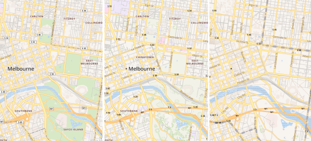
My quick little proof of concept in NodeJS converted OpenMapTiles’ “OSM Bright” style (left) to versions for Mapbox Streets (centre) and Mapzen (right).
Want to give me a hand? Get in touch!
| arnebab on 10 things I hate about Gi… | |
| arnebab on 10 things I hate about Gi… | |
| arnebab on 10 things I hate about Gi… | |
| Smitty on 10 things I hate about Gi… | |
| Igor on 10 things I hate about Gi… |

really cool… could you do a full walkthrough of setting them up?
Pingback: weeklyOSM 371 | weekly – semanario – hebdo – săptămânal – haftalık – 週刊 – týdeník – edisi
Very decent. Is there any tutorial/setup to run this style in maputnik?
There is an onto mapping MA: OSM -> SchemaA/StyleA, and another onto mapping MB: OSM -> SchemaB/StyleB. (Not stricly onto, some elements map to NULL – they are dropped). So to go from B to A is just Inv(MB) * MA. Of course the function Inv(MB) may contain some ambiguities as MB is an onto function, And then some of the values in the image of Inv(MB) also map to NULL though MA. Nevertheless, as you showed in your example, it’s good enough. And you can make a speedy LUT for Inv(MB) * MA.
Where do you apply this transformation? On the fly on the server side as tiles are requested?
I’m also wondering if there is possible interference with this issue: https://github.com/osm2vectortiles/osm2vectortiles/issues/387.
I did the transformation as a one time conversion of a Mapbox style.json.