National Map is a pretty awesome place to find geospatial open data from all levels of Australian government. (Disclaimer: I work on it at NICTA). But thanks to some not-so-obvious features in TerriaJS, the software that drives it, you can actually create and share your own private version with your own map layers – without programming, and without deploying any code.
What you get:
- A 3D, rotateable, zoomable globe, thanks the awesome Cesium library. (It seamlessly falls back to Leaflet if 3D isn’t available.)
- Selectable layers, grouped into an organised hierarchy of your devising
- Support for a wide range of spatial services: WMS, WFS, ESRI (both catalogs and individual layers for all of these), CKAN, individual files like GeoJSON and KML, and even CSV files representing regions like LGAs, Postcodes, States…
- Choose your own basemap, initial camera position, styling for some spatial types, etc.
1. Make your own content with online tools
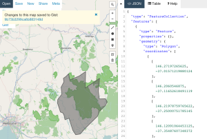
Want to create your own spatial layer – polygons, lines and points? Use geojson.io and choose Save > Gist to save the result to Github Gist. (Gist is just a convenient service that stores text on the web for free).
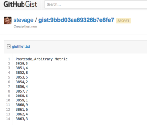
How about a layer of data about suburbs by postcode? Create a Google Sheet that follows the csv-au-geo specification (it’s easy!), download as CSV, paste it into a fresh Gist.
2. Create a catalog with the Data Source Editor
Using the new TerriaJS Data Source Editor (I made this!), create your new catalog. You’re basically writing a JSON file but using a web form (thanks json-editor!) to do it.
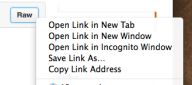
To add one of your datasources on Gist, make sure you link to the Raw view of the page:

Don’t forget to select the type for each file: GeoJSON, CSV, etc.
3. Add more data
You might want to bring in some other data sources that you found on National Map. This can be a little tricky – there’s a lot of complexity in accessing data sources that National Map hides for you.
But here’s roughly how to go about it for a WMS (web map service) data source.
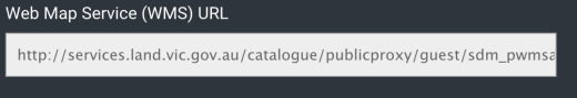
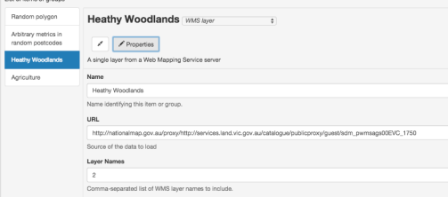
In the layer’s info window, grab the WMS URL
You’ll need to put “http://nationalmap.gov.au/proxy/” in front of a some layers, because their WMS servers don’t support CORS.
You’ll also need the value of the “Layer name” field. (For Esri layers you need to dig a bit further.)
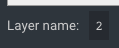
(Yes, this layer is called “2”)
Add a WMS layer, and add “Layers Names” as an additional property. So it looks like this:
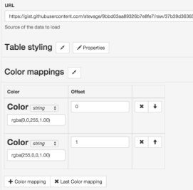
4. Tweak your presentation
You can add extra properties to layers to fine tune their appearance. For example, for our CSV dataset:
You might want to set “Is Enabled” and “Is Shown” on every layer so they display automatically.
And finally, you might want to set an initial camera and base map, so the view doesn’t start off the west coast of Africa with a satellite view.

5. Save and preview
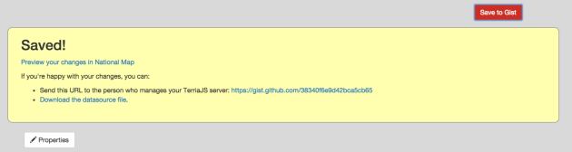
As you make changes, click “Save to Gist” to save your configuration file to a secret location on Gist. You can then click “Preview your changes in National Map”.
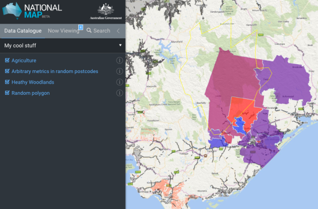
Make a note of the Gist link so you can keep working on it in the future. You can’t modify an existing configuration, but you can load from there and save a new copy.
6. Share!
Now you have a long URL like this: http://nationalmap.research.nicta.com/#clean&https%3A%2F%2Fgist.githubusercontent.com%2Fanonymous%2Fc3f181ca742b9ed94fe4%2Fraw%2F10853f7d8bb33610e4f2ce26947eaf6882192957%2Fdatasource.json
So, use tinyurl.com or another URL shortening service to get something more useful:
http://tinyurl.com/myawsummap


Recent Comments